
Parcel 41-4N-23-2100-0003-0030
Owners
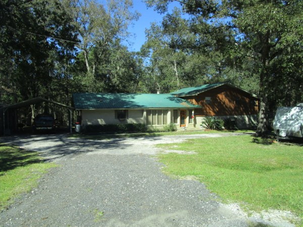
28288 LAKE HAMPTON ROAD
HILLIARD, FL 32046
Parcel Summary
| Situs Address | 28288 LAKE HAMPTON RD |
|---|---|
| Use Code | 0100: SINGLE FAMILY |
| Tax District | 4: Nassau County |
| Acreage | .0000 |
| Section | 41 |
| Township | 4N |
| Range | 23 |
| Subdivision | ST MARYS HIGHLAND PB 5/12 |
| Exemptions | HX: Homestead (196.031(1)(a)) (100%) HB: Homestead Banded (196.031(1)(ab) (100%) |
Short Legal
BLOCK 3 LOTS 3 & 4IN OR 888/1381
EX R/W IN OR 106/450...
Certified Values
| STANDARD | 2024 |
|---|---|
| Land Value | $60,000 |
| (+) Improved Value | $269,318 |
| (=) Market Value | $329,318 |
| (-) Agricultural Classification | $0 |
| (=) Assessed Value | $160,427 |
| (=) County Taxable Value | $110,427 |
Document/Transfer/Sales History
| Instrument / Official Record | Date | Q/U | V/I | Sale Price | Ownership |
|---|---|---|---|---|---|
| WD 1151/1918 | 2003-07-09 | U | Improved | $130,000 | Grantor: NEWKIRK GEORGE E JR & ANGELA D Grantee: HINSON FERRELL & DIANA |
| WD 0888/1381 | 1999-06-25 | Q | Improved | $94,000 | Grantor: PANOS TAMI R Grantee: NEWKIRK GEORGE E JR & ANGELA D |
| WD 0766/0513 | 1996-07-24 | Q | Improved | $93,700 | Grantor: LLOYD RONNIE H Grantee: PANOS NICHOLAS & TAMI |
| QC 0766/0511 | 1996-07-24 | U | Improved | $1,100 | Grantor: DICKENS G L P/R Grantee: LLOYD RONNIE |
| QC 0764/1322 | 1996-07-08 | Q | Improved | $30,000 | Grantor: LLOYD LINDA DIANE Grantee: LLOYD RONNIE H |
| QC 0532/1290 | 1987-12-14 | U | Improved | $60,000 | Grantor: CREWS MICHAEL & C B Grantee: LLOYD RONNIE & DIANE |
| WD 0438/0550 | 1984-11-01 | Q | Improved | $80,500 | |
| MS 0335/0088 | 1981-04-01 | U | Vacant | $4,700 |
Buildings
Building # 1, Section # 1, 266562, RESIDENTIAL
| Heated Sq Ft | Year Built | Value |
|---|---|---|
| 3110 | 1983 | $276,656 |
Structural Elements
| Type | Description | Code | Details |
|---|---|---|---|
| EW | Exterior Wall | 20 | FACE BRICK |
| EW | Exterior Wall | 12 | CEDAR |
| RS | Roof Structure | 03 | GABLE/HIP |
| RC | Roof Cover | 12 | MODULAR MT |
| IW | Interior Wall | 04 | PLYWOOD |
| IW | Interior Wall | 05 | DRYWALL |
| IF | Interior Flooring | 08 | SHT VINYL |
| IF | Interior Flooring | 14 | CARPET |
| AC | Air Conditioning | 03 | CENTRAL |
| HT | Heating Type | 04 | AIR DUCTED |
| BDR | Bedrooms | 4.00 | |
| BTH | Bathrooms | 3.00 | |
| FR | Frame | 02 | WOOD FRAME |
| STR | Stories | 1.5 | 1.5 |
| BUD8 | BUD8 Adjustment | 04 | DIST 01 |
Extra Features
Land Lines
Personal Property
None
TRIM Notices
Property Record Cards
Disclaimer
The Nassau County Property Appraiser's Office makes every effort to produce the most accurate information possible. No warranties, expressed or implied, are provided for the data herein, its use or interpretation. The information contained herein is for ad valorem tax assessment purposes only. The Property Appraiser exercises strict auditing procedures to ensure validity of any transaction received and posted by this office but cannot be responsible for errors or omissions in the information received from external sources. Due to the elapsed time between transactions in the marketplace, and the time that those transactions are received from the public and/or other jurisdictions, some transactions will not be reflected.